
For almost as long as I’ve lived in New York, one of my favorite pastimes has been exploring it, not under the streets via the subway, but on them, by bike. One of the first things I bought for myself a few months after I moved here was a clunker found off Craigslist that was almost as old as I was at the time. I had never ridden a bike once before in my life, but for weeks I walked it out to the long, flat and mercifully wide promenade of East River Park, said a prayer or two, and have been riding ever since.
But as vibrant and diverse as New York City can be, sometimes one needs a change, so after a little bit of reconnaissance on Google Maps and elsewhere, and hungry to take in some fall foliage, I discovered what looked like the ideal autumn cycling escape: the Old Croton Aqueduct Trail.

A marvelous example of 19th century engineering that, like much of America, was built by immigrant labor, the Old Croton Aqueduct (OCA) is an underground conduit built to carry water 41 miles from the Croton River south to New York City. The conduit was slanted 13 inches per mile for its entire length, so the water was driven entirely by gravity, emptying out in two reservoirs in the city, one at the present location of Bryant Park and the main branch of the New York City Library, the other at what is now the Great Lawn in Central Park.
Within fifty years the ever-expanding (and ever-thirsty) city outgrew it, and the OCA was essentially replaced by the New Croton Aqueduct. The OCA was officially decommissioned in 1955, and afterward the state turned 26 miles of it into an historic park with a hiking trail.
Nature? Check. Curious historic infrastructure? Check. Close proximity to the Metro-North in case I chicken out midway? Sign me up!
My game plan was pretty straightforward. I live in Brooklyn, and the idea of riding all the way to the river towns and back did not appeal at the time, so I decided to take the subway to the last stop of the 1 line at Van Cortlandt Park. From there, I was to make my way through the park to the South County Trailway at the Westchester County border, ride that up to Tarrytown, make my way west to the OCA, and then ride back down to the city. No sweat, right?
Well, I should have done a bit more research.
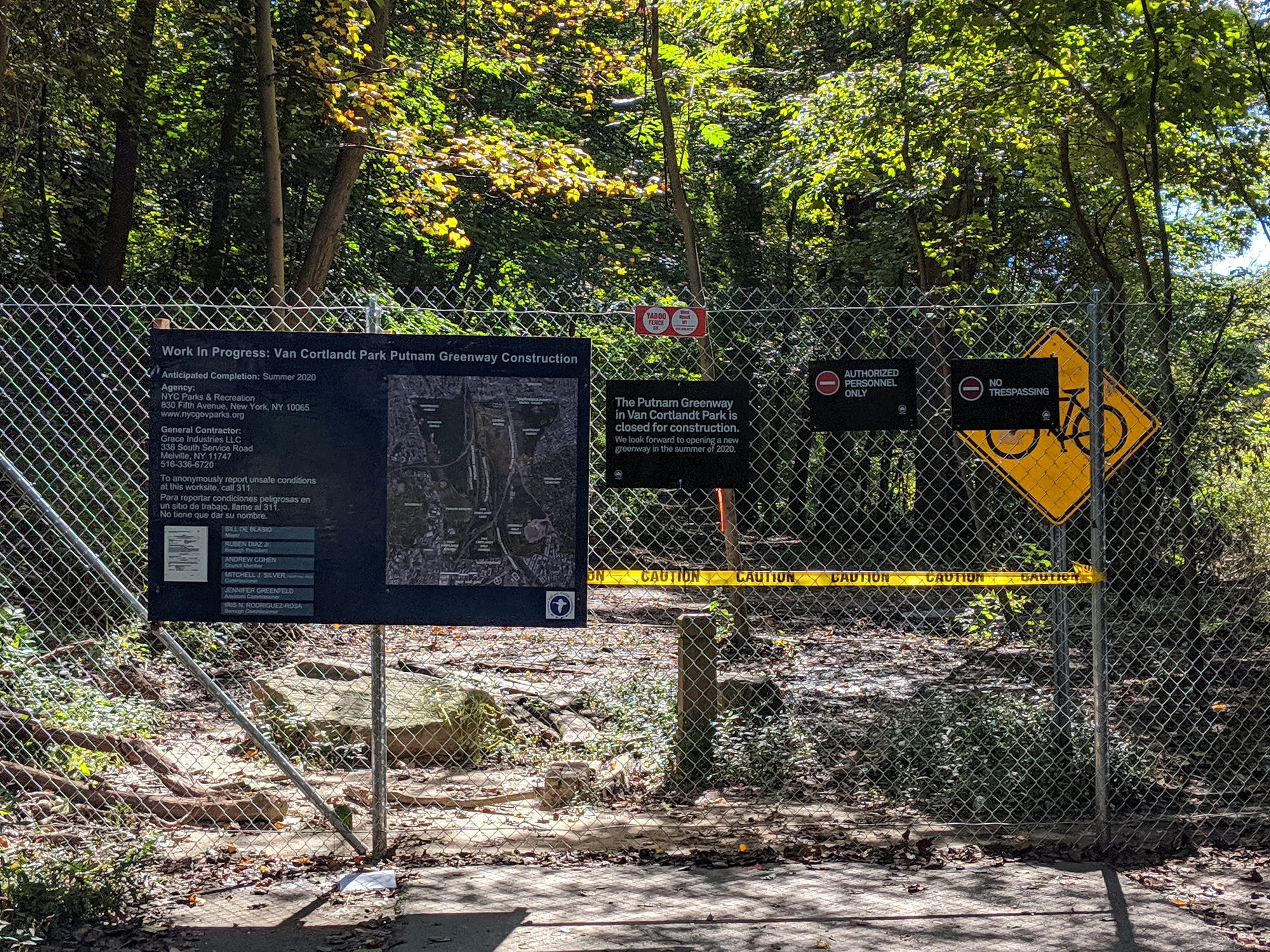
I learned this lesson quickly enough as soon as I left the train, only to find about three thousand teenagers in track shorts milling around for some massive cross country race. An exasperated bunch of track volunteers waved me away from any path that Google Maps told me might lead me to the trailhead. Eventually, I finally found a very rough, barely trod, suggestion of a path upon which I could walk my bike northbound along the edge of a golf course to the trail… until I couldn’t. Unbeknownst to me at the time, the main access route to the South County through the park, the Old Putnam Trail (which I was hiking parallel to, apparently) was closed off for construction until Summer 2020. I was informed of this only by stumbling upon the back side of a tall, chain link fence decorated with ominous “No Trespassing” signs — after spending at least a half hour getting there. It was the only way I could reach the trail unless I doubled back, so in the interest of not losing any more precious time I lugged my bike through the brush and simply went around the fence (and another) until I finally reached the trail. They can’t fence off the whole forest!
(Disclosure: I don’t recommend disregarding fences and “No Trespassing” signs, but it was Saturday, and I was cranky.)
After at least an hour lost in the park, I finally made it to the South County Trailway, a paved bike and pedestrian-friendly rail-to-trail path that follows along the Saw Mill Parkway up through Yonkers and Greater Westchester County. This leg of my journey was the fastest, despite having to hoist my bike over three downed trees along the way (there was a storm a few days before).

The path out of Yonkers and a little beyond is pretty smooth, allowing for big gear hustling, but fair word of caution: Afterward the road can get pretty choppy with lots of frost heaves and tree roots. Add to that a heavy leaf cover (I went in early November, which is peak foliage season in these parts) obscuring the road hazards, and it’s actually somewhat unpleasant unless you watch your speed.
Honestly, maybe this would be a good time to mention that I wouldn’t necessarily recommend this ride on a road bike. Both the South County and the OCA trails are relatively flat, but the OCA has its own fair share of rocks, roots, and ruts, and can be tiring especially if you’re more used to riding on pavement (like I am). I have a hybrid bike, and despite a recent tune-up both trails reduced it to a rattling mess. At one point, riding south on the OCA near the entrance to the Untermyer Gardens, I hit something that twisted my rear fender 360 degrees into a pretzel (unfortunately I was too panicked at the sight to grab a pic). You will slip, you will scrape rocks, and your bottom will take a beating. Do bring a patch kit (and maybe a padded seat) if you can.
Anyway, though it can be a bit noisy at times since the Saw Mill Parkway runs directly above it on an embankment, the South County takes you through Tibbetts Brook Park (“a refuge from urban living, an oasis of green surrounded by the city”) and along some pretty suburban country for a bit, with a few stop offs where you can rest by the Saw Mill River. I decided to have a break and a Cliff Bar by the waterfall at the Great Hunger Memorial Park, just before reaching the next leg of my journey.

(Note: From here on out, an asterisk indicates a link to Google Maps, for ease of route planning. I am horrible at navigation, so I like to reconnoiter future trips with Maps and Street View.)
The South County ends rather abruptly* in Elmsford, where you have to cross West Main Street and connect with the North County Trailway to keep going, well, north, up past Yorktown Heights if you wish. I decided to continue up a ways and pull off by the parking lot on Bedford Road* to go southeast near Kykuit, the Rockefeller estate, which is a great destination in itself for another ride — I might even suggest Blue Hill at Stone Barns too but it might be difficult to bring the required jacket and tie with you on the ride. If you don’t want to spend the extra time (about 45 minutes) to go the long way around, an alternate route east is to exit the North County Trail on the south side of the Tarrytown Reservoir, near Old Saw Mill River Road.*
When you see the spires of the new Mario Cuomo bridge (it will always be Tappan Zee to me), you will have reached Tarrytown proper, a cute river town that gets pretty crowded with city folk on the weekends. Feel free to lock up and recharge for lunch or some light shopping, but get ready — this is where we finally meet the Old Croton Aqueduct Trail! This is also where things can get a bit tricky.
In towns and villages, the OCA Trail is often split into segments that can be hard to find if you don’t know what to look for. You might be riding along and then the trail will suddenly terminate at a main road and it won’t be very obvious at first where the next entry point is. Generally, all you need to do is ride in the same direction a little bit and you’ll come across the next segment, but in a few places you’ll have to ride with traffic in the street for a few blocks before meeting the other side.
When navigating, keep an eye out for one of three waypoints: a fairly new-looking two-foot-tall stone marker, a dark green post with “OCA” marked on it, and sometimes a more modern sign from the NY State Park service.


There are helpful signs in some places informing you of detours*, but I recommend that you bring an extra battery for your phone or that you top it off in town, because that first time you ride this you will be looking for the dotted green line in Google Maps a lot.
Anyway, from Tarrytown center I decided to go down Broadway to Leroy Ave*, where I met the trail running alongside some random parking lot for a medical building. Under leafy canopies and suburban meadows, the trail runs right through the middle of town parallel to Broadway, yet still feels somewhat out of sight. It’s a very active trail however, as I passed neighborhood teens killing time, families walking their dogs, as well as a few occasional joggers along the wide, dirt and gravel path.

You’ll soon find that the OCA cuts right through the property* of the Lyndhurst estate, one of many opulent relics of crazy rich, dead white guys in the area. Built in 1838 by A.J. Davis and William Paulding, the Gothic Revival mansion and grounds were owned by several wealthy notables over the years, including Jay Gould, the owner at the time of Western Union. His daughter, Anna Gould, gifted the estate to the National Trust for Historic Preservation upon her death in 1961, leaving it open to the public (and future wedding planners).

Not wanting to waste too much time, I opted to pedal around the lovely grounds a bit before I pressed on to Irvington, where, feeling peckish, I made a stop for lunch at the Black Cat Cafe. Their menu is huge — I opted for a spicy honey lime chicken sandwich, which certainly hit the spot. Definitely recommended!
Back up the hill on West Main Street and continuing south on the OCA along the river, you’ll ride alongside the backyards of some very lovely, very expensive mansions, some of which prove the adage that money often can’t buy taste (sorry, stucco north of the Mason-Dixon Line is not okay). For a stretch, the path even runs through the front yards of some houses within spitting distance from their front steps, as if the foundations were built on top of the aqueduct itself. I wonder how that affects their property values?

In Dobbs Ferry, be sure to stop by the Keeper’s House on Walnut Street,* where a caretaker responsible for the inspection and upkeep of a particular section of the aqueduct lived. It’s now a museum maintained by the Friends of the Old Croton Aqueduct, from whom I gleaned most of the history of the aqueduct reported here.
As you venture south, you’ll notice a few notable relics of the actual infrastructure. In intervals along the way, the trail is marked by one of eighteen solitary stone columns — ventilation towers designed to alleviate pressure in the tunnel. A few “weir” houses are along the way as well, where the aqueduct could be drained and serviced when the need arose.


Gradually, the closer you get to Yonkers, the trail unfortunately loses much of its charm, resembling something more like a trash-strewn back alley behind some apartment buildings where instead of dodging rocks, you’re dodging debris from stripped A/C units.
The trail stops abruptly at Bishop William J. Walls Place*, where you’ll have to continue down North Broadway, take a left at Ashburton Avenue, and then meet the trail again at Palisade Avenue. Someone did install this handy pump/tool station though at the intersection of Walnut Street!*

At Prescott Street, the trail stops again,* and at that point the traffic to the interchange for the Saw Mill Parkway and the Cross County Parkway gets pretty busy. I took Yonkers Avenue east to where it runs under the South County Trailway— thankfully there are a set of stairs next to the bridge for you to get back up to it.
As the light faded I took the South County south back through Tibbetts Brook Park, this time pulling off where it meets Alan B. Shepard Jr. Place.* Go south along Tibbetts Road, then head west along McLean Avenue and Caryl Avenue until you hit Broadway, which is your ticket back into the city.
All in all, according to Strava my ride totaled about 62 miles over six and a half hours of riding time, a chunk of that from skipping the train on the return home in favor of riding the Greenway along the west side of Manhattan, crossing the Brooklyn Bridge, and then onward home to Bed-Stuy, where I live.
It was kind of a challenging ride for what I had intended, but in smaller chunks and without the threat of darkness pushing you along, one could derive more than a few future day trips, with the possibility for plenty more adventures along the way.
More info from Atlas Abscura here.
